
Pipeline & Mapping Visibility
SHEETCUTTER PRO
Map Your Path To Real Value
SheetCutter Pro
Driving Value and Efficiency Through Pipeline Alignment Sheet Generation Tools
Ready to learn more about the efficiencies that alignment sheets can drive?
Click here to download a free infographic
Enhancing Pipeline Mapping and Visibility
Integration
The SheetCutter Pro application can be used with ArcGIS Pro, making it the first ArcGIS Pro alignment sheet generation application available
Streamlined Workflow
Offers a user-friendly interface that enables seamless visibility and navigation capabilities
Compatibility
Works seamlessly with Pipeline Open Data Standard (PODS) 4.02, PODS 7, Utility and Pipeline Data Model (UPDM), and other models
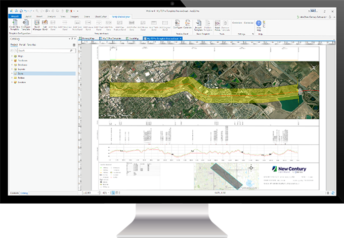
Sample view of SheetCutter Pro for ArcGIS Pro sheet generation
SheetCutter Pro: Ensure Pipeline Integrity with Custom Alignment Sheets
Pipeline alignment sheets can be time-consuming to create and difficult to analyze and are typically disconnected from multiple data sources. By utilizing New Century’s SheetCutter Pro application, users are poised to experience improved design time, an integrated view of various data sources on a single page, and a boost in overall efficiency. With SheetCutter Pro, users will have a higher level of confidence that their pipeline maps are giving an accurate, easily accessible, integrated view of their pipeline integrity conditions.
With data integration at the heart of pipeline integrity management, this unique application provides automated alignment sheets that provide critical insight to better understand the environment, assets, inspections, threats, and release consequences near a pipeline. SheetCutter Pro offers a flexible, user-friendly interface designed to create value-driven alignment sheets aimed at saving valuable time and money.
Core Benefits
SheetCutter Pro has been designed with Integrity Operations personnel in mind, from data analysts to integrity engineers. New Century’s alignment sheets are built to help enhance mapping, visibility, and integration. With SheetCutter Pro, users will experience a highly efficient, streamlined application that ensures pipeline data is effectively managed, mapped, and retrieved.
- Quickly generate alignment sheets for improved quality assurance
- Visualize data from a variety of sources in one location
- Data model independence
- Esri ArcGIS Pro integration
- Seamless integration with TemplateDesigner Pro and SheetCutter Server Pro for additional pipeline integrity program efficiencies
See How Alignment Sheets Can Drive Pipeline Mapping Efficiencies
DownloadAlignment Sheet Types
Not all alignment sheets require the same elements. SheetCutter Pro offers the capabilities and functionalities to design the right alignment sheet, for the right job. See below for the various pipeline alignment sheets that the solution is typically used for.
- As-built engineering
- New construction design/planning
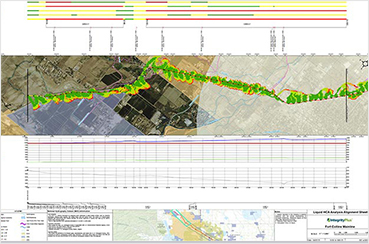
- Pipeline Integrity sheet showing Inline Inspections (ILI), Close Interval Survey (CIS), crossings,
- geohazards, waterways, etc.
- Pipeline risk sheet showing release consequences, threats, inspections, repairs, Maximum Allowable Operating Pressure (MAOP), etc.
- MAOP reconfirmation sheet – showing all components of MAOP calculation
- Hazardous Liquid Spill Impact Analysis – showing
- High Consequence Areas (HCA) areas and release plumes
- Gas pipeline Class Location and HCA Analysis – showing structures and Class/HCA polygons
- LI feature/box comparison sheet
- Roads & Highways Straight Line Diagram (SLD) sheet
See How Alignment Sheets Can Drive Pipeline Mapping Efficiencies
DownloadKey Features
SheetCutter Pro gives users the power to craft detailed alignment sheets to meet their unique pipeline mapping needs. This is made possible by providing access to a range of platforms and tools for a streamlined mapping experience.
- Connect to File or Personal Geodatabase, Access, Oracle, or SQL Server databases
- Dynamic matchline calculation
- Apply multi-line reporting to a single sheet
- Flexible template designs using various band types
See How Alignment Sheets Can Drive Pipeline Mapping Efficiencies
DownloadTechnical Specifications
SheetCutter Pro seamlessly integrates across a variety of platforms to enhance flexibility for its users.
- ArcGIS Pro
- SQL Server
- Oracle
- Microsoft Windows 10
- Microsoft Windows Server
- Microsoft .NET
- Industries: Pipeline, Petroleum, Transportation
See How Alignment Sheets Can Drive Pipeline Mapping Efficiencies
DownloadMore Resources
If you still have questions, download the SheetCutter Pro Infographic below or contact New Century to learn how this application can drive value through custom alignment sheets.