Skip links

Gas HCA Analyst

Gas HCA Analyst

Gas HCA Analyst

Request Info Watch Video
Integrity Management

Increase HCA and class location accuracy

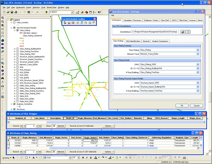
Gas HCA Analyst is a software application that determines how many structures fall within proximity of a pipeline (Class Location) and identifies high consequence areas (HCA) and regulated onshore gathering lines. GIS analysts and technicians use this tool to quickly, accurately, and reliably run the analysis and prepare for submittal to meet DOT regulations.

Gas HCA Analyst’s advanced design follows a “show your work” philosophy. This means every Class Location and HCA determination is accompanied by detailed project settings and metadata critical for project validation. Gas HCA Analyst also allows you to pull pipeline data from a variety of databases and generate the results in both tabular and geospatial formats, meeting the diverse needs of various departments that need to review the results.

Gas HCA Analyst increases productivity by automating the analysis and reducing errors that often occur with manual analysis. It saves configuration settings that are unique to your integrity management framework so you can use them in the future to drive consistent results and generate time-based comparisons along the pipeline network.

Preview Product

Highly configurable calculation settings address the framework of a company’s integrity management program.

Preview Product

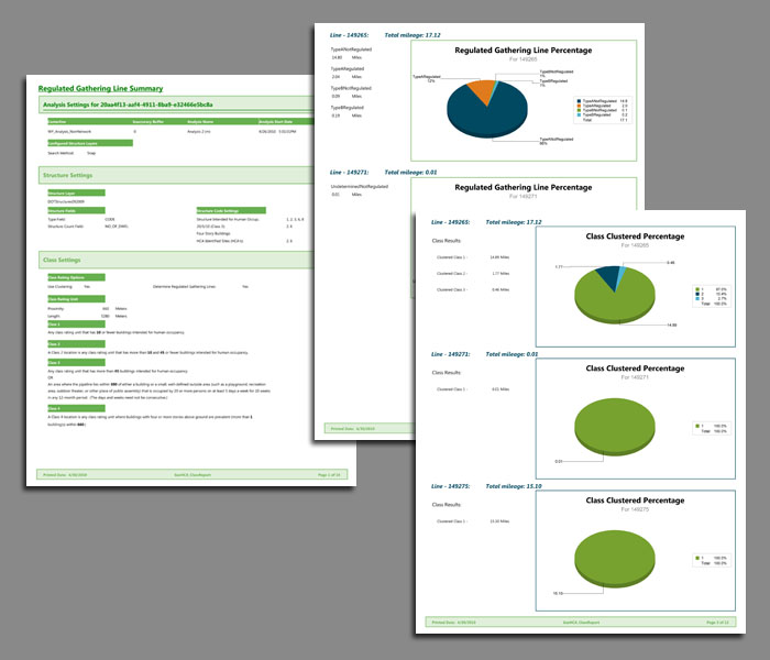
Pre-configured templates in Crystal Reports enhance the reporting and output options.

Request a Product Demo

Request Demo

Watch the Product Video

Watch

Download Product Brochure

Download

  • Increases accuracy, reliability, and the speed of analysis.
  • Provides an intuitive interface that lets users easily walk through the analysis process.
  • Meets the diverse needs of users with its flexibility:
    • Supports all Esri formats for layers containing structure data (feature class, shape file, points, and polygons).
    • Is not data model-dependent (you can connect to any database or no database).
    • Lets you compare analysis results as features in ArcMap or as tables of information.
  • Gives you the ability to create “what-if” scenarios that simulate data changes on the pipeline network to analyze the effects of a proposed action.
  • Aids in understanding and validation by providing “behind the scenes” data along with the high-level results.
  • Allows continuous analysis across pipelines for Class Locations, provides user-defined buffers for areas where the centerline may be in question, and applies clustering methods so you can produce precise Class Location results.

  • Addresses three major DOT regulations to keep you compliant: 49 CFR 192.5 Class Location determinations; 49 CFR 192.903 High Consequence Area identification; and 49 CFR 192.8 Regulated Gathering Line determinations.
  • Performs both Class Location and HCA analysis within an attribute or geometric network.
  • Supports Moderate Consequence Area (MCA) analysis.
  • Accesses pipeline data directly from an Oracle, SQL Server, or Access database, regardless of data model.
  • Exports analysis results to tabular files or ArcMap feature classes.
  • Stores configuration settings such as database connections, buffers, and structure classification.
  • Associates structures with the pipeline using the snap method.
  • Identifies the reasoning behind an HCA determination.
  • Sets default values for pipe data when it is unavailable or when you need to perform “what-if?” scenarios.

  • ArcGIS Desktop
  • Oracle, SQL Server, Access
  • Windows 7 or Windows 10
  • Windows .NET Framework

GAS HCA ANALYST is a trademark or registered trademark of New Century Software, Inc. Third party trademarks, trade names, product names and logos may be the trademarks or registered trademarks of their respective owners.